
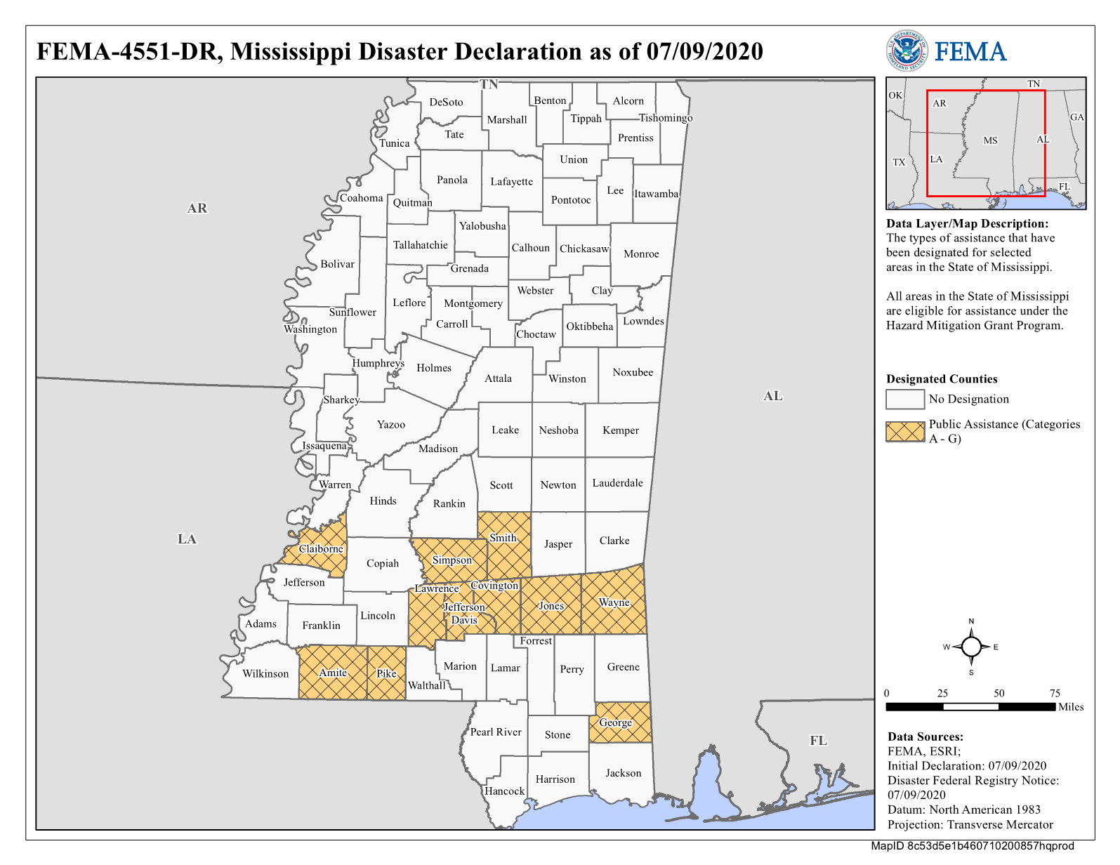
 Incident Period: April 22, 2020 - April 23, 2020Declaration Date: July 9, 2020
PDF of map
Google Earth
Need help with this map?
Financial Assistance
If and when financial assistance is approved for this disaster, it will be displayed here. Information is updated every hour.
Disaster Assistance
For more information on getting assistance after a disaster visit our Individual Assistance page
Original linkOriginal author: Anonymous
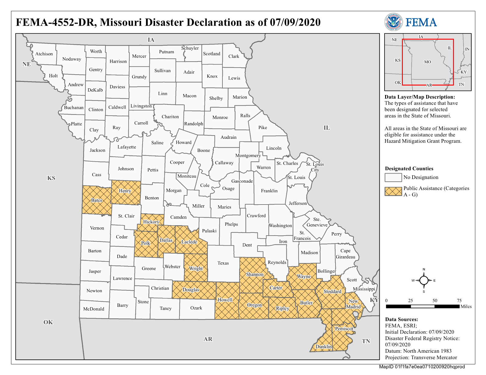
Incident Period: April 22, 2020 - April 23, 2020Declaration Date: July 9, 2020
PDF of map
Google Earth
Need help with this map?
Financial Assistance
If and when financial assistance is approved for this disaster, it will be displayed here. Information is updated every hour.
Disaster Assistance
For more information on getting assistance after a disaster visit our Individual Assistance page
Original linkOriginal author: Anonymous 
Jul
10
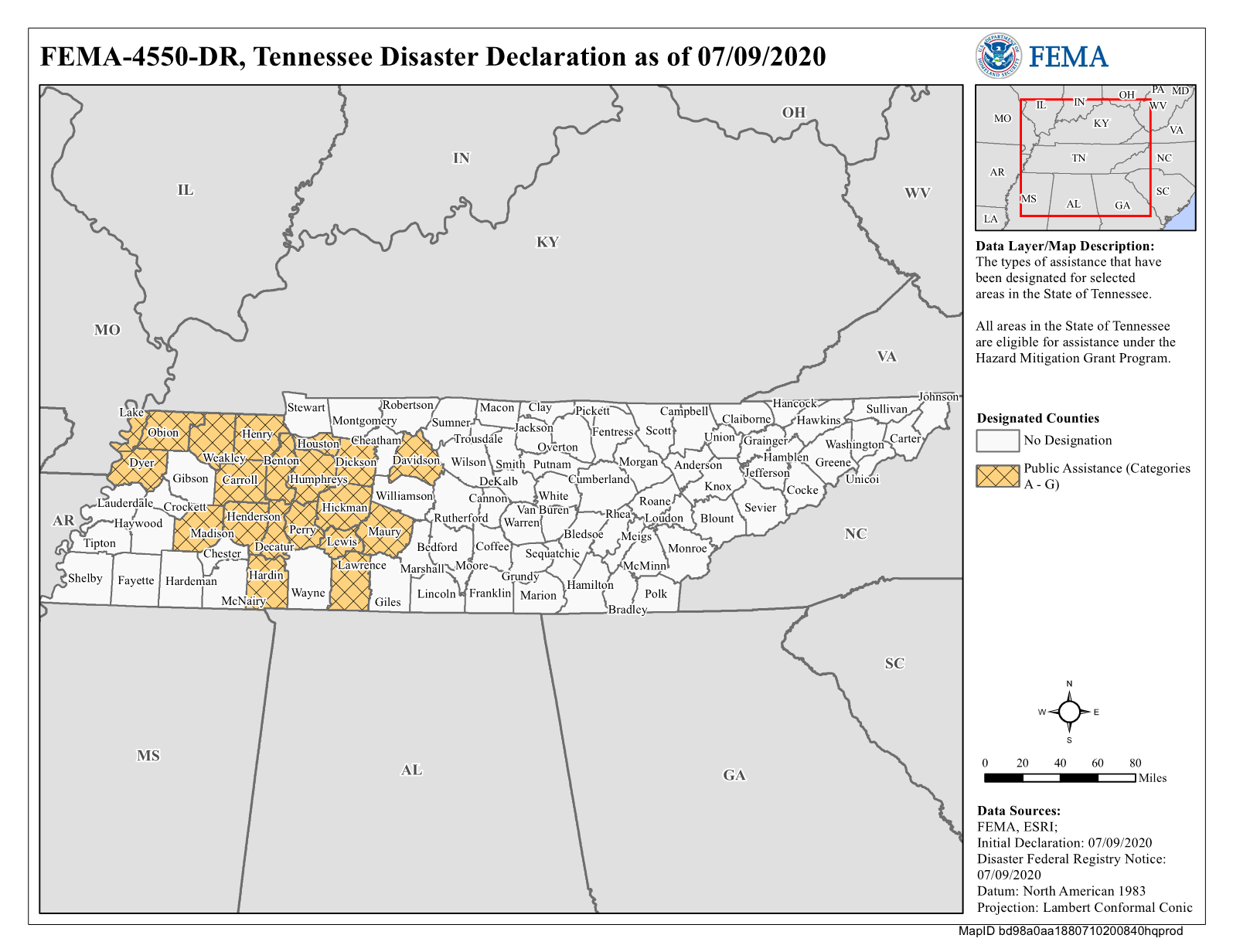
Incident Period: April 22, 2020 - April 23, 2020Declaration Date: July 9, 2020
PDF of map
Google Earth
Need help with this map?
Financial Assistance
If and when financial assistance is approved for this disaster, it will be displayed here. Information is updated every hour.
Disaster Assistance
For more information on getting assistance after a disaster visit our Individual Assistance page
Original linkOriginal author: Anonymous
Jul
10
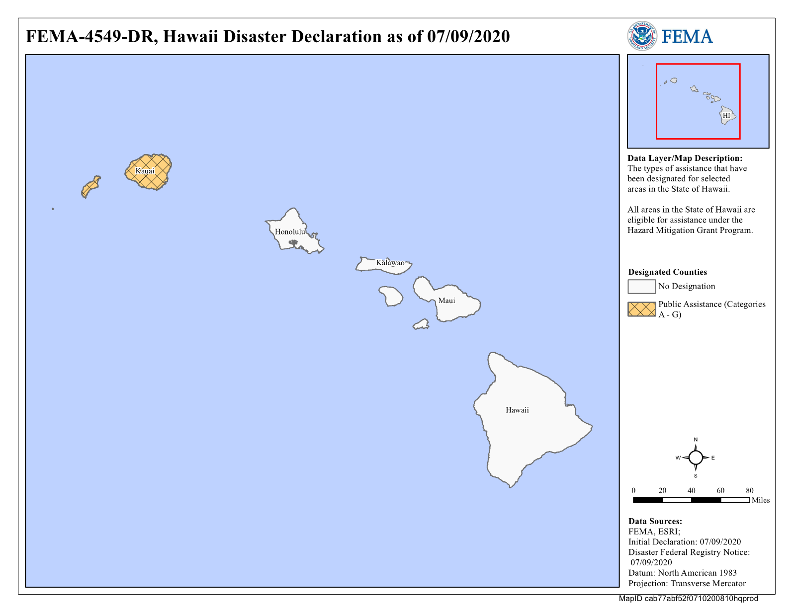
 Incident Period: May 3, 2020 - May 4, 2020Declaration Date: July 9, 2020
PDF of map
Google Earth
Need help with this map?
If and when financial assistance is approved for this disaster, it will be displayed here. Information is updated every hour.
Original linkOriginal author: Anonymous
Incident Period: May 3, 2020 - May 4, 2020Declaration Date: July 9, 2020
PDF of map
Google Earth
Need help with this map?
If and when financial assistance is approved for this disaster, it will be displayed here. Information is updated every hour.
Original linkOriginal author: Anonymous
Jul
10
 Incident Period: March 27, 2020 - March 28, 2020Declaration Date: July 9, 2020
PDF of map
Google Earth
Need help with this map?
If and when financial assistance is approved for this disaster, it will be displayed here. Information is updated every hour.
Original linkOriginal author: Anonymous
Incident Period: March 27, 2020 - March 28, 2020Declaration Date: July 9, 2020
PDF of map
Google Earth
Need help with this map?
If and when financial assistance is approved for this disaster, it will be displayed here. Information is updated every hour.
Original linkOriginal author: Anonymous
Jul
10
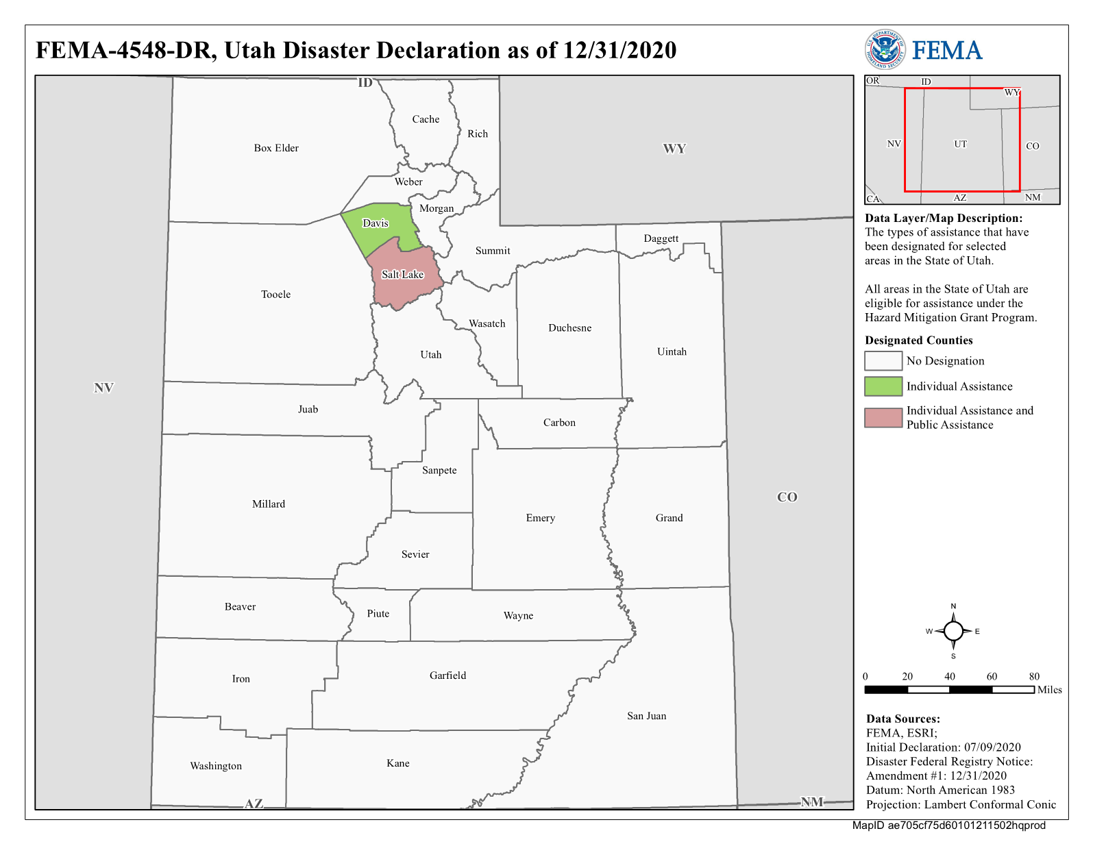 Incident Period: March 18, 2020 - April 17, 2020Declaration Date: July 9, 2020
PDF of map
Google Earth
Need help with this map?
Financial Assistance
Disaster Declaration
Amount
Individual Assistance Applications Approved
47
Total Individual & Households Program Dollars Approved
$154,406.98
Total Housing Assistance (HA) - Dollars Approved
$154,306.98
Total Other Needs Assistance (ONA) - Dollars Approved
$100.00
Hazard Mitigation Grant Program (HMGP) - Dollars Obligated
$0.00
Designated Counties (Individual Assistance)
Davis (County)
Salt Lake (County)
Original linkOriginal author: Anonymous
Incident Period: March 18, 2020 - April 17, 2020Declaration Date: July 9, 2020
PDF of map
Google Earth
Need help with this map?
Financial Assistance
Disaster Declaration
Amount
Individual Assistance Applications Approved
47
Total Individual & Households Program Dollars Approved
$154,406.98
Total Housing Assistance (HA) - Dollars Approved
$154,306.98
Total Other Needs Assistance (ONA) - Dollars Approved
$100.00
Hazard Mitigation Grant Program (HMGP) - Dollars Obligated
$0.00
Designated Counties (Individual Assistance)
Davis (County)
Salt Lake (County)
Original linkOriginal author: Anonymous
Jul
10
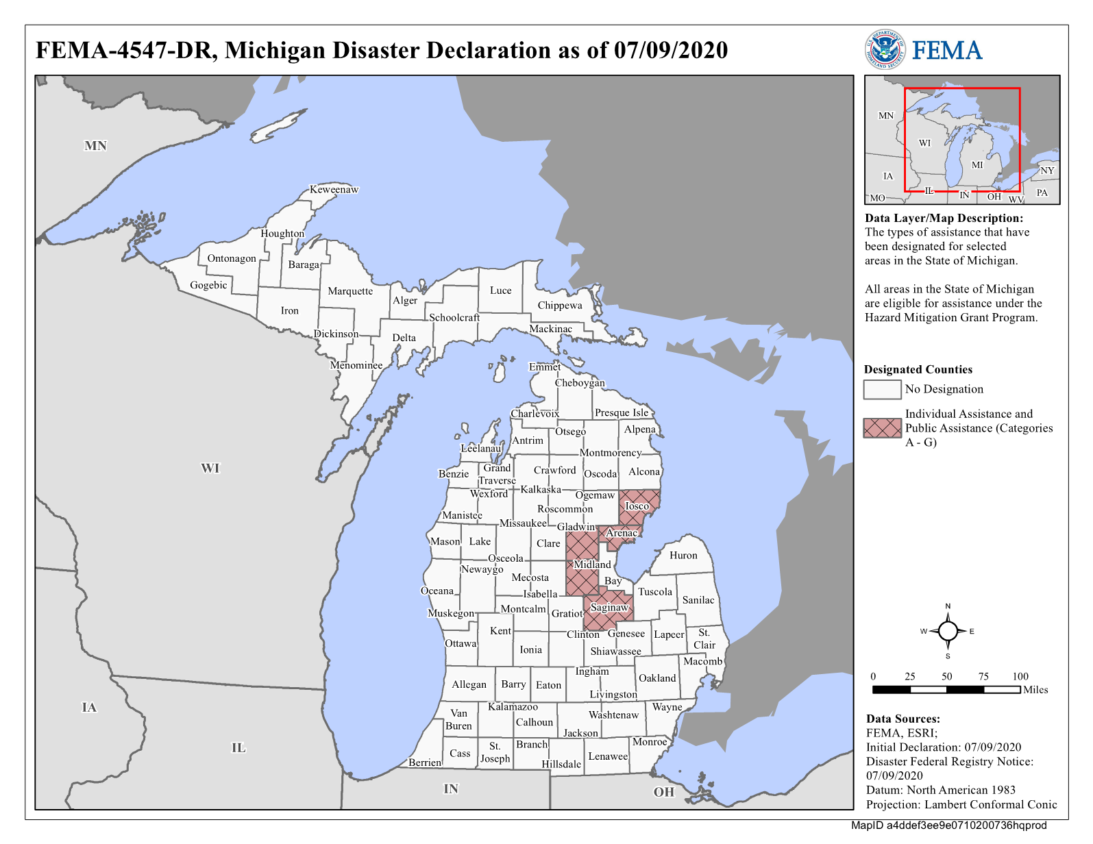 Incident Period: May 16, 2020 - May 22, 2020Declaration Date: July 9, 2020
PDF of map
Google Earth
Need help with this map?
Financial Assistance
Disaster Declaration
Amount
Individual Assistance Applications Approved
1371
Total Individual & Households Program Dollars Approved
$15,593,244.88
Total Housing Assistance (HA) - Dollars Approved
$15,132,900.07
Total Other Needs Assistance (ONA) - Dollars Approved
$460,344.81
Hazard Mitigation Grant Program (HMGP) - Dollars Obligated
$0.00
FEMA Mitigation Resources
For information on the resources available for mitigation measures, e-mail This email address is being protected from spambots. You need JavaScript enabled to view it..
For questions on flood insurance, visit FloodSmart.gov or call the Flood Mapping and...
Incident Period: May 16, 2020 - May 22, 2020Declaration Date: July 9, 2020
PDF of map
Google Earth
Need help with this map?
Financial Assistance
Disaster Declaration
Amount
Individual Assistance Applications Approved
1371
Total Individual & Households Program Dollars Approved
$15,593,244.88
Total Housing Assistance (HA) - Dollars Approved
$15,132,900.07
Total Other Needs Assistance (ONA) - Dollars Approved
$460,344.81
Hazard Mitigation Grant Program (HMGP) - Dollars Obligated
$0.00
FEMA Mitigation Resources
For information on the resources available for mitigation measures, e-mail This email address is being protected from spambots. You need JavaScript enabled to view it..
For questions on flood insurance, visit FloodSmart.gov or call the Flood Mapping and...
Jul
09
FEMA Daily Operations Briefing for July 9, 2020
National Current Operations & Monitoring
Significant Incidents or Threats: Severe thunderstorms possible – Southern/Central Plains; Mississippi Valley; Great LakesHeavy rain and flash flooding possible – Southern/Central Plains; Mississippi Valley; Great LakesCOVID-19
Tropical Activity:
Atlantic: Invest 98L – High (80%)Eastern Pacific: Tropical Storm CristinaDisturbance 1 – Medium (60%)Central Pacific: No new tropical cyclones expected during the next five daysWestern Pacific: No activity affecting U.S. interests
Declaration Activity: Major Disaster Declaration Request - Mississippi
FEMA Daily Ops Briefing 07-09-2020.pdf
Update Your E-mail Address |...
Jul
08
DENTON, Texas – Preliminary Flood Insurance Rate Maps (FIRMs) are available for review by residents and business owners in all communities and unincorporated areas of El Paso County. Officials encourage property owners to review the latest information to learn about local flood risks and potential future flood insurance requirements. This is El Paso County’s first set of digital Flood Insurance Rate Maps (FIRMs). FIRMs serve multiple purposes, including defining Special Flood Hazard Areas (SFHAs) and setting rates for flood insurance. SFHAs are areas at high risk for flooding. Communities and residents can...
Jul
08
FEMA Daily Operations Briefing for July 8, 2020
National Current Operations & Monitoring Significant Incidents or Threats:• Severe thunderstorms possible – Central Plains to Upper Mississippi Valley• Heavy rain and flash flooding possible – Central Plains and Upper Mississippi Valley• Critical fire weather possible – Southwest, Central Great Basin and Central Rockies• COVID-19Tropical Activity:• Atlantic: Invest 98L – High (70%)• Eastern Pacific:• Tropical Storm Cristina• Disturbance 1 – Medium (40%)• Disturbance 2 – Medium (40%)• Central Pacific: Disturbance 1 – Low (10%)• Western Pacific: No activity affecting U.S. interestsDeclaration Activity:• Amendment...
Jul
07


 Lifecycle - Medical Animation")


")


Urban Search & Rescue News
District Dustoff bolsters partnership with local Urban Search & Rescue - DVIDS
District Dustoff bolsters partnership with local Urban Search & Rescue DVIDS
5 canines get sworn in as members of FEMA search and rescue...
5 canines get sworn in as members of FEMA search and rescue team KABC-TV
How LA Fire Urban Search and Rescue teams went global after Northridge...
How LA Fire Urban Search and Rescue teams went global after Northridge quake LA Daily News
More urban search-and-rescue teams needed in Pa. | Opinion - The Philadelphia...
More urban search-and-rescue teams needed in Pa. | Opinion The Philadelphia Inquirer
When disaster strikes, these FEMA rescue dogs are sent to the front...
When disaster strikes, these FEMA rescue dogs are sent to the front lines NPR
Tropical Storms
Coastal Bend Hurricane Conference preps community for 2024 season | kiiitv.com -...
Coastal Bend Hurricane Conference preps community for 2024 season | kiiitv.com KIIITV.com
Huricane Season - The Robesonian
Huricane Season The Robesonian
Down 7-0, Hurricane rallies but falls a run short to Warriors -...
Down 7-0, Hurricane rallies but falls a run short to Warriors Wilmington News Journal, OH
Prep softball sectionals: Hurricane run-rules Parkersburg in postseason opener - Huntington Herald...
Prep softball sectionals: Hurricane run-rules Parkersburg in postseason opener Huntington Herald Dispatch
The Rolling Stones Crossfire Hurricane Rum Drops New Gift Box - Robb...
The Rolling Stones Crossfire Hurricane Rum Drops New Gift Box Robb Report
Earthquakes
Magnitude 4.5 Earthquake Strikes Near Nikolski, Aleutians West, Alaska, USA...
Magnitude 4.5 Earthquake Strikes Near Nikolski, Aleutians West, Alaska, USA VolcanoDiscovery
Magnitude 5.2 Earthquake Strikes Near Riohacha, La Guajira, Colombia |...
Magnitude 5.2 Earthquake Strikes Near Riohacha, La Guajira, Colombia | VolcanoDiscovery VolcanoDiscovery
Light mag. 4.5 earthquake - North Pacific Ocean, 60 mi...
Light mag. 4.5 earthquake - North Pacific Ocean, 60 mi southeast of Herbert Island, Aleutians West, Alaska, United ... VolcanoDiscovery
Moderate mag. 4.4 earthquake - Caribbean Sea, 64 km west...
Moderate mag. 4.4 earthquake - Caribbean Sea, 64 km west of Maicao, La Guajira, Colombia, on Thursday, May 2 ... VolcanoDiscovery
Moderate mag. 4.0 earthquake - Fox Islands, Aleutian Islands, on...
Moderate mag. 4.0 earthquake - Fox Islands, Aleutian Islands, on Thursday, May 2, 2024, at 07:24 am (Universal Time ... VolcanoDiscovery